Premodern communication technology that emerged and developed in Korea:
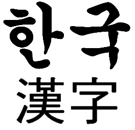
#1 Hangul (한글): Korean alphabet

and on the bottom are Hanja (Chinese)
China influenced Korea’s civilisation since the earliest dynasties and one of the most prominent contributions it gave was writing. Before Korea had a writing system, they adopted Chinese characters and it was not until the 15th century that King Sejong introduced Hangul.
Today, each Korean letter has a Chinese equivalent, making it easier to understand what a word means if one knows the translation. But this by no means suggests that the two languages are similar as, for example, Chinese has an SVO (subject-verb-object) construction whereas Korean has an SOV construction.
The main reason for King Sejong to create a new set of alphabets was because Chinese characters were complex and only the intellectuals learned to speak and communicate in it fluently. Hangul thus became a secondary writing system that the illiterate masses could learn more quickly and use it. Hanja (Chinese characters) were still used as the primary language associated with elite status and Hangul as the vernacular language.
The movement to use Hangul began in late 19th century more as a tool of resistance when Japanese colonized Korea (1910-1945). Koreans were forced to adopt Japanese names and were punished when they used their own language. Textbooks were reproduced in Japanese and they removed courses on Korean history and geography, which were central in teachings of national identity. It was in this period that the current rules of spelling and standard language for Korean developed. After the liberation, there was a push for the exclusive usage of Hangul.
#2 Cartography: Korean maps
One of the earliest surviving maps in Korea portraying the country in 5th to early 7th century was found on the wall of a tomb in Pyongan province. There were some concerns about Chinese security as their maps were being exported to Korea. Two maps that have survived before the Japanese invasion in of 1952 are Kangni-do and another by Yi Hoe and Kwon Kun. It’s believed that ‘Buddhist maps’, also known as ‘maps of the five Indian kingdoms,’ were invented in Korea.
The first form of the world map was called a ‘wheel map,’ which featured a large continent containing both China and Korea surrounded by water, which is also surrounded by a circular land mass that is again surrounded by a circular sea.
New approaches came after Ricci’s world map arrived in Korea in 1603 and paved way for different types of maps. The use of each map varied, such as to illustrate written materials in historico-geogrpahical texts and to help merchants understand the topography and communication routes better as inter-regional commerce developed (maps in style of Cho Sanggi).
One of the most famous maps was that of Kimg Chongho, which is praised today as the finest product of Korea’s traditional geography. He was not a geographer and spent 30 years wandering up and down the Korean peninsula to gather information. He added towns, military bases, and government offices. But the government was afraid that this map could be used by their enemy and arrested Kim.
Bibliography:
http://s-space.snu.ac.kr/bitstream/10371/85783/1/11.%202234478.pdf
http://asianhistory.oxfordre.com/view/10.1093/acrefore/9780190277727.001.0001/acrefore-9780190277727-e-192
https://books.google.ae/books?id=r15cAgAAQBAJ&pg=PA36&lpg=PA36&dq=korea+wheel+map&source=bl&ots=bgsKvfXUYA&sig=Yww6CF_sTR6aApNPs_gQJsCP4bE&hl=en&sa=X&ved=2ahUKEwiD0drarOPdAhUF4YUKHQECCgYQ6AEwCXoECAkQAQ#v=onepage&q=korea%20wheel%20map&f=false
http://eds.a.ebscohost.com/eds/pdfviewer/pdfviewer?vid=1&sid=7698c9f9-a7c5-4671-835b-47fc5738df4e%40sdc-v-sessmgr06